Maps from the 3rd Era
During Thellian’s 3rd Era, immortals have faded from the world, and humans live in Askar. The lands beyond are no longer habitable.
Askar
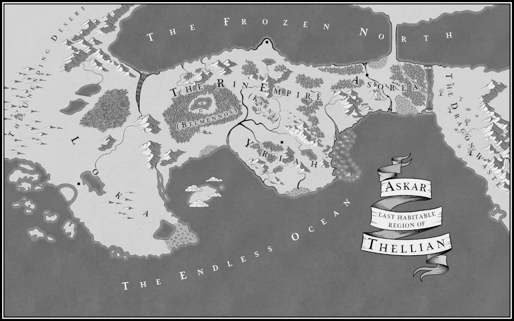
A map of Askar, the last habitable region of Thellian.
The area of land shown is wide with a sea to the north, The Frozen North, and an ocean to the south, The Endless Ocean. To the west is The Unending Desert, and to the east beyond a wide river is The Dragon Waste.
Taking up around a third of the core landmass is Loka in the west, a country shaped like a wide incisor curving down to the southeast. Loka extends further to the south than other countries, coming to about three-quarters of the way down the map. On the southwest coast of Loka is the capital, nestled between a bay with a curved island filling it and an enormous rhinoceros-shaped lake. To the southwest of Loka are scattered islands. The southeastern tip of Loka has a lake partially surrounded by marshland that extends to the ocean. The northwest and southeast of Loka are deserts, while the north is predominantly occupied by a jungle. West of the jungle is a large lake shaped like an upside-down droplet. Across the lake, east to west, is an arching land bridge.
Loka borders Rin in the east, separated by mountains on the southern stretch and a wide river running to the north. The river has treacherous rapids its full length.
The top half of the map’s central area is The Rin Empire, an area of mountains, forests, and rivers. The empire’s original land is in the northeast of the middle kingdoms, bordering the northern sea. In the middle of the northern coastline, the land pushes north with towering cliffs. At the tip of this area is the Rinnite capital. South of there is a lake, and south again is a Y-shaped mountain range. Southeast of there is another mountain range that marks part of Rin’s border with Yriah. Much of eastern Rin is covered by forests.
A huge forest in western Rin was formerly the nation of Belmennos. There is a lake in the middle of the forest, and within it is an island with a single tree. The Belmennian capital is on the southern edge of this lake. It borders The Endless Ocean in the south, where there is a large marsh. In the east, a river borders Karna and Yriah. The river is formed from four sources, three of which join close together, making the river look like a crooked dead tree leaning to the east. I sometimes non-canonically call it The Hydra.
In the very centre of Rin is a small area that was formally the nation of Karna. It has two small forests, some hills, and a lake. The Karnan capital is central, east of the lake.
South of the eastern half of the middle kingdoms is a country called Yriah. It stretches from a river border with Belmennos and Karna in the northwest, towards the ocean in the southeast. It has a large coastline, running southeast from Belmennos, northeast, then north up to Rin. On its southernmost stretch of coastline is a large marsh with a river flowing into it from the north that looks like a rat’s tail. Yriah borders Rin in the north, separated by mountains and a river (one of the four sources mentioned earlier). Yriah’s capital is just south of the river. South of the capital are forests and mountains.
In the ocean to the east of Yriah and southern Rin is an area of jagged, half-submerged mountains.
On the eastern side of Askar, between Rin and The Dragon Waste, is Asorea. It is the shortest land area, being half the height of Rin. It is separated from Rin by a large mountain range and a forest on its western border. On Asorea’s eastern border is a very wide river that stretches from a waterfall near The Frozen North to a waterfall leading into The Endless Ocean. Another river runs north to south the full height of Asorea, splitting the nation in two. East of the river, the north and south coastlines both have large marshes. Much of Asorea’s eastern half is covered by a forest, which has a river running through it northwest to southeast. Halfway down Asorea, between the forest and the central river, are three enormous canyons like jagged rips. In the north, between Asorea’s northern marsh and the eastern forest, a land bridge runs up into The Frozen North, which is unnaturally straight.
The coastline from the southern point of Loka runs north, then curves east beneath Belmennos and southeast in Yriah. In this area between the three countries is a large island like a pointed oval with a much smaller island to its east. Clouds hover over the islands.
In the far eastern part of the map, The Dragon Waste runs from level with the north of Asorea down to level with the tip of Loka, curving eastwards off the map. Its west is an area of barren land, shown with dead trees and a dragon skeleton. In the east, it has a long mountain range running north to south, with a volcano just visible in the southeast.
Eastern Askar
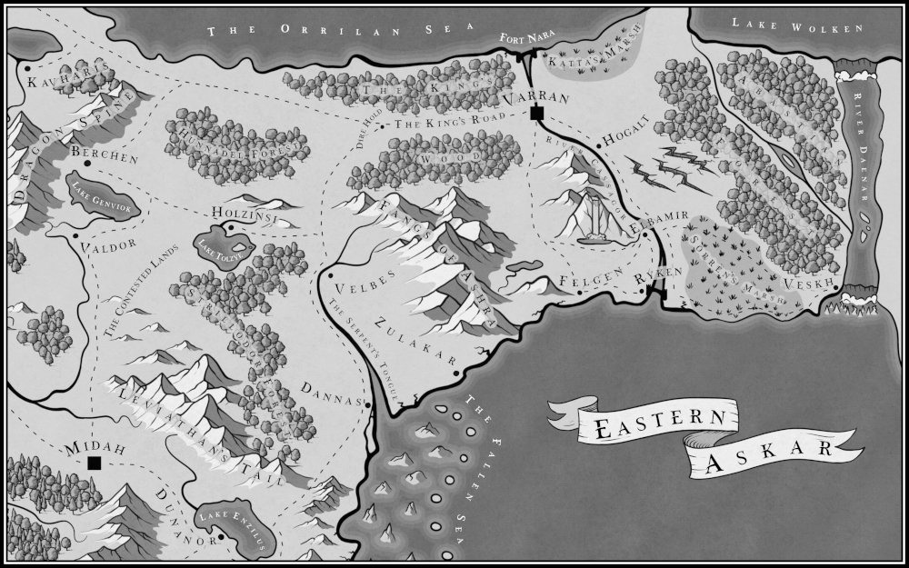
A map of Eastern Askar, showing eastern Rin in the west and Asorea in the east, as well as a small section of northern Yriah to the south of Rin.
Rin and Asorea are separated in the centre of the map by a border running north to south, mostly made up of a mountain range called the Fangs of Ashra, as well as a forest north of those called The King’s Wood. Dividing the forest east to west is a wide road called The King’s Road. At the eastern end of the King’s Road is Varran, Asorea’s capital. A large river flows through Varran, running from The Orrilan Sea on the north coast all the way to the ocean on the south coast. The River Cassagor has large forts at either end: Fort Nara in the north and Ryken in the south.
North of Ryken, a quarter of the way along the River Cassagor, is Elbamir, which has a large mountain to its west with a towering waterfall. North along the river from Elbamir, halfway to the capital, is Hogalt. On the south coast of Asorea, west of Ryken and nestled beside the Fangs of Ashra mountains, is Felgen.
In the very southeast of Asorea is Veskh, a town with Sorren’s Marsh to its west, the Abastian Forest to its north, and the very wide River Daenar to its east. North of the river, separated from Asorea by cliffs, is Lake Wolken, which is big enough to be a sea. Between the Abastian forest and the central part of the River Cassagor are three huge canyons like jagged rips, as if a god-like creature gouged the land with its claws.
On the border between Asorea and Rin, at the western end of The King’s Road and The King’s Wood, is Dire Hold. A road from Dire Hold curves southwest into Rin around the Fangs of Ashra and then south, leading to a forked river, The Serpent’s Tongue, and a town just over the river called Velbes. A short way north of the river, the road is joined by another that heads west to Lake Tolzye and the town of Holzinsi on the lake’s northern shore. The road continues west and a little north to Berchen, a town nestled between Lake Genviok to the south and the Dragon Spine mountains to the west. Between Berchen and Dire Hold is the Hunnadel Forest.
South of the lake near Berchen is a town called Valdor, and south of that is a hilly area called The Contested Lands. South of The Contested Lands, across a river, is Midah, the capital of Yriah. Northeast of Midah are the Leviathan’s Tail mountains. Northeast of those, stretching up to Lake Tolzye, is the sizeable Strillodor Forest. East of the forest near the estuary of The Serpent’s Tail is the town of Dannas. Across the river and along the coast to the northeast is Zulakar. In the ocean to the south between Dannas and Zulakar is an area of jagged partially-submerged mountains called The Fallen Sea.
At the bottom of the map, south of the Leviathan’s Tail, is Lake Enzilus. Southwest of the lake is Dunnador. In the very northwest of the map, northwest of the Dragon Spine mountains, is an unlabelled lake with a town south of it called Kavharis.